Navigation System -- System Description |
| NAVIGATION SYSTEM OUTLINE |
Vehicle position tracking methods
It is essential that the navigation system correctly tracks the current vehicle position and displays it on the map. There are 2 methods to track the current vehicle position: autonomous (dead reckoning) and GPS* (satellite) navigation. Both navigation methods are used in conjunction with each other.
*: GPS (Global Positioning System)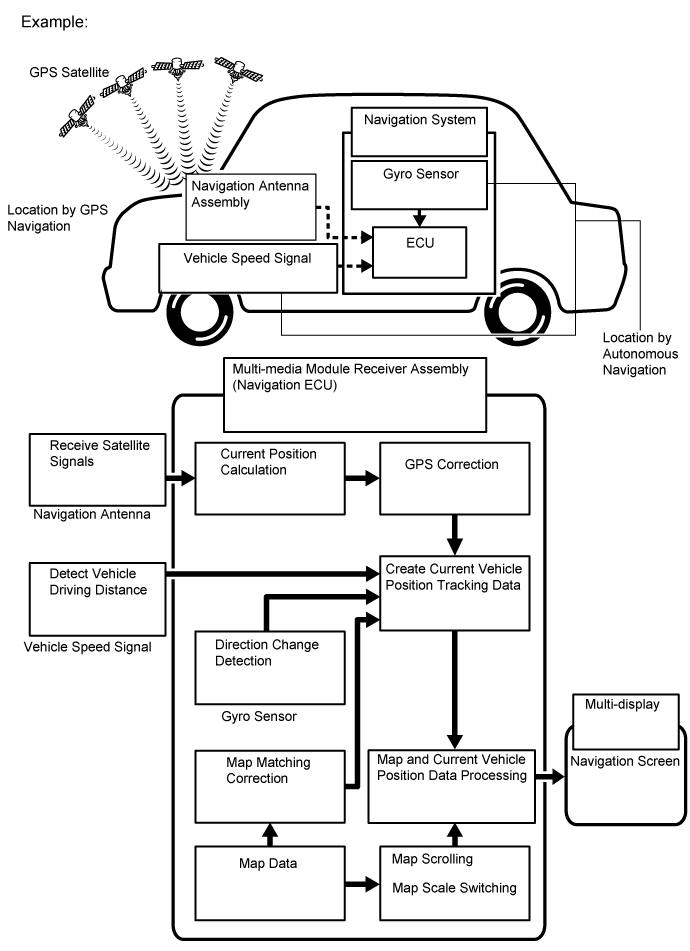
Operation Description Vehicle Position Calculation The multi-media module receiver assembly calculates the current vehicle position (direction and current position) using the direction deviation signal from the gyro sensor and driving distance signal from the vehicle speed sensor and creates the driving route. Map Display Processing The multi-media module receiver assembly processes the vehicle position data, vehicle driving track and map data from the hard disc. Map Matching The map data from the hard disc is compared to the vehicle position and driving track data. Then, the vehicle position is matched with the nearest road. GPS Correction The vehicle position is matched to the position measured by the GPS. Then, the GPS measurement position data is compared with the vehicle position and driving track data. If the position is very different, the GPS measurement position is used. Distance Correction The vehicle speed signal includes error caused by tire wear and slippage between the tires and road surface. Distance correction is performed to account for this. The multi-media module receiver assembly automatically offsets the signal to make up for the difference between the distance signal and distance data of the map. The offset is automatically updated. 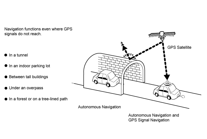
- HINT:
- The combination of autonomous and GPS navigation makes it possible to display the vehicle position even when the vehicle is in places where GPS signals cannot be received. When only autonomous navigation is used, however, the mapping accuracy may slightly decrease.
Autonomous navigation
This method determines the relative vehicle position based on the driving track determined by the gyro located in the multi-media module receiver assembly and the vehicle speed signal.Gyro sensor
Used to calculate the direction by detecting angular velocity. It is located in the multi-media module receiver assembly.Vehicle speed signal
Used to calculate the vehicle driving distance.
GPS* navigation (Satellite navigation)
This method detects the absolute vehicle position using radio waves from GPS satellites.
*: GPS satellites were launched by the U.S. Department of Defense for military purposes.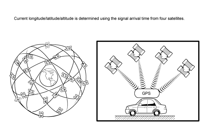
Number of Satellites Measurement Description 2 or less Measurement is impossible Vehicle position cannot be obtained because the number of satellites is not enough. 3 2-dimensional measurement is possible Vehicle position is obtained based on the current longitude and latitude. (This is less precise than 3-dimensional measurement.) 4 3-dimensional measurement is possible Vehicle position is obtained based on the current longitude, latitude and altitude. Map matching
The current driving route is calculated by autonomous navigation (according to the gyro sensor and vehicle speed signal) and GPS navigation. This information is then compared with possible road shapes from the map data in the hard disc and the vehicle position is set onto the most appropriate road.
| TOUCH SWITCH |
Touch switches are touch-sensitive (interactive) switches operated by touching the screen. When a switch is pressed, the outer film bends in to contact the inner glass at the pressed position. By doing this, the voltage ratio is measured and the pressed position is detected.

| DVD (Digital Versatile Disc) PLAYER OUTLINE |
The DVD player can only play DVD videos that have any of the following marks:

The following products may not be playable on your player.
- Video CD
- DVD+R
- DVD+RW
- DVD-RAM
- Video CD
Precaution for use of discs
- NOTICE:
- SECAM color television standard discs cannot be played.
- Keep the discs away from dirt. Be careful not to damage the discs or leave fingerprints on them.
- Hold discs by the outer edge and center hole with the label side up.
- Leaving the disc exposed halfway out of the slot for a long time after pressing the disc eject button may cause deformation of the disc, making the disc unusable.
- Do not use odd-shaped discs because these may cause player malfunctions.
- Do not use discs whose recording portion is transparent or translucent because they may not be inserted, ejected or played normally.
- DualDiscs that mate DVD recorded material on one side with CD digital audio material on the other cannot be played.
| "Bluetooth" OUTLINE |

| *a | Multi-media Module Receiver Assembly (Built-in "Bluetooth" receiver antenna) | *b | Portable Audio Player ("Bluetooth" compatible type) |
| *c | Cellular Phone ("Bluetooth" compatible type) | *d | Cellular Tower |
"Bluetooth" is a trademark owned by Bluetooth SIG, Inc.
"Bluetooth" is a wireless connection technology that uses the 2.4 GHz frequency band.
- HINT:
- The communication performance of "Bluetooth" may vary depending on obstructions or radio wave conditions between communication devices, electromagnetic radiation, communication device sensitivity or antenna capacity.
Hands-free function
The "Bluetooth" built-in multi-media module receiver assembly and a "Bluetooth" compatible cellular phone* can be connected using a "Bluetooth" wireless connection. This enables the use of the hands-free function on the cellular phone even if the phone is in a pocket or bag. For this reason, it is not necessary to use a connector or cable to connect the cellular phone.
*: Some versions of "Bluetooth" compatible cellular phones may not function.Compatible hands-free devices
Required "Bluetooth" specifications Ver. 1.1 or higher (Ver. 2.1+EDR or higher recommended) Compatible profiles - HFP (Hands Free Profile) Ver.1.0 or higher (Ver.1.5 or higher recommended)*1
- OPP (Object Push Profile) Ver.1.1 or higher*1
- PBAP (Phone Book Access Profile) Ver.1.0 or higher*1
- MAP (Message Access Profile) Ver.1.0 or higher*2
- DUN (Dial-Up Networking Profile) Ver.1.1 or higher*3
Maximum number of hands-free devices that can be registered (including audio devices) 5 - *1: This profile is necessary when using the handsfree function.
- *2: This profile is necessary when using the message function. (w/ Connected Services)
- *3: This profile is necessary when using the connected services. (w/ Connected Services)
- HINT:
- The amount of remaining battery charge displayed on the multi-media module receiver assembly may be different from that of the "Bluetooth" device.
- HFP (Hands Free Profile) Ver.1.0 or higher (Ver.1.5 or higher recommended)*1
| CONNECTED SERVICES OUTLINE (w/ Connected Services) |
The following services are available by connecting the navigation system to Toyota's portal site via the internet using a cellular phone.
- Online search: New establishments, such as restaurants, bars, etc., that are not registered in the navigation system can be set as a destination.
- Importing memory points: Establishments that were searched using a personal computer can be set as a destination and can be registered as memory points.
- HINT:
- For known compatible phones refer to www.my.toyota.eu.
- It is necessary to agree to the terms of service for the search engine on www.my.toyota.eu.
Failure to do so may cause problems such as the search engine cannot be selected and the screen does not transfer to the next screen even when "Online search" is selected. - If the cellular phone has not been registered as a registered device, the "Communication settings" screen button cannot be selected.
- Connected services are available only on the multi-media module receiver assembly that has had the identification code registered when the account was created.
- Search results may not be displayed if the target establishment is not in the data supplied by the provider or in the map data of the navigation system.
- As the information for a destination set using the connected services is supplied by the provider, the navigation system may guide to a location that deviates from the actual destination.
- Online search: New establishments, such as restaurants, bars, etc., that are not registered in the navigation system can be set as a destination.
| EXPORT / IMPORT MEMORY POINT FUNCTION OUTLINE |
This function allows memory points stored in the multi-media module receiver assembly to be registered to another multi-media module receiver assembly.
Memory points stored in the multi-media module receiver assembly can be exported to a USB device.
Data exported to a USB device can be imported to another multi-media module receiver assembly using a USB device.
| RDS-TMC FUNCTION OUTLINE (w/ RDS-TMC Function) |
This system has a function which allows the reception of traffic information from Radio Data System Traffic Message Channel (RDS-TMC) stations based on FM-multiple broadcasting.
It assists the driver to avoid areas with traffic congestion. It also helps to improve traffic flow and road safety.RDS-TMC Function List
- Traffic information
Using RDS-TMC station based on FM-multiple broadcasting or TPEG information* that is received, traffic events near the current position or the cursor position can be viewed as a list. - Traffic prediction*
Using TPEG information that is received, traffic prediction information relevant to the area around the current position or the cursor position can be viewed. - Parking information*
Using TPEG information that is received, the location available spaces of a parking lot can be checked. The parking lot can also be set as a destination.
- *: Can only be used when receiving TPEG (Transport Protocol Experts Group) information. Depending on the country or area, receiving TPEG information may not be possible.
- HINT:
- The following is information regarding the RDS-TMC function that utilizes TPEG information:
- When the vehicle enters an area where TPEG information can be received, TPEG information can be received only after the vehicle has been driven for 1 km (0.6 miles) or more in the coverage area.
- Detoured route search activates only when traffic information within 200 km (124 miles) exists.
- If there is traffic information only for traffic congestion, the route may not be changed depending on the distance of the congestion.
- If there is no available avoidance route, the route may not be changed.
- Provided data may differ from actual condition.
- TPEG information uses the same signal reception path as the DAB function.
- Traffic information
| VEHICLE CUSTOMIZATION OUTLINE |
- HINT:
- Items available for customization via the navigation system can be performed by using the intelligent tester.
- Some customize parameters displayed on the intelligent tester will be displayed on the "Vehicle Customization" screen for the navigation system. Users can customize these items.
| COMMUNICATION SYSTEM |
MOST Network Outline
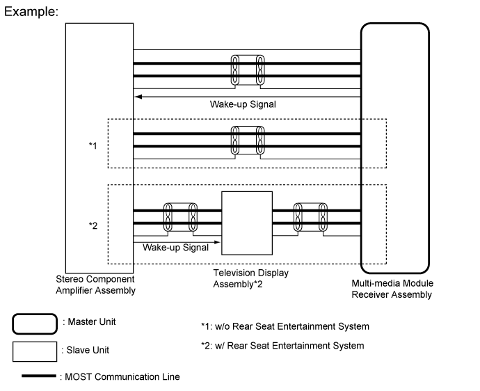
Navigation system components communicate with each other via the MOST network.
The MOST network uses a shielded twisted pair of wires for its communication lines.
The master unit of the MOST network is the multi-media module receiver assembly.
MOST communication lines connect each slave unit centering around the master unit to form a MOST network ring.
The master unit sends a wake-up signal to activate each slave unit connected to the MOST network.
- HINT:
- If a short or open circuit occurs in the MOST circuit, communication will be interrupted and the system will not operate normally.
AVC-LAN Outline
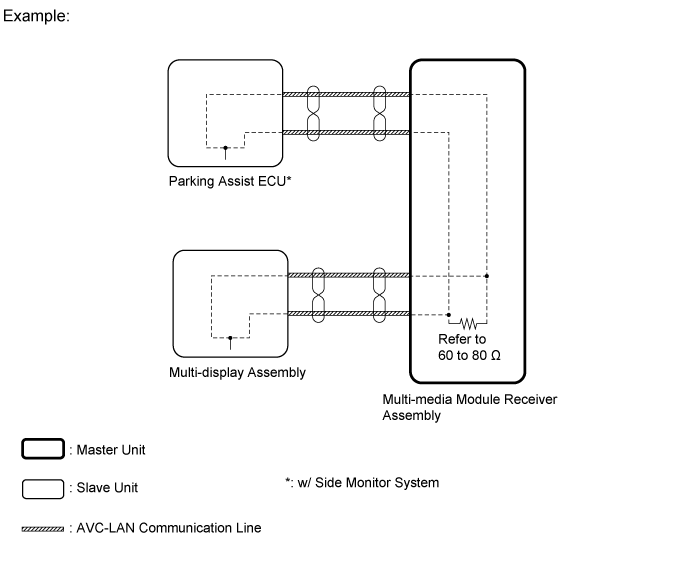
Components of the navigation system communicate with each other via the AVC-LAN.
The AVC-LAN uses a twisted pair of wires for its communication lines.
The master unit of the AVC-LAN is the multi-media module receiver assembly.
- HINT:
- The multi-media module receiver assembly has the resistance (60 to 80 Ω) necessary for communication.
- If a short or open circuit occurs in the AVC-LAN circuit, communication is interrupted and the system will not operate normally.
| DIAGNOSTIC FUNCTION OUTLINE |
The navigation system has a diagnostic function (the result will be displayed on the master unit or the intelligent tester).